History of Denver’s Valverde Neighborhood
Discover the rich heritage of Valverde Neighborhood with Silver Stem Fine Cannabis.
As part of the City of Denver Department of Excise and Licenses “Cannabis Cares” program, Silver Stem Fine Cannabis is working on educate its employees working at its Denver locations on the history of the neighborhood where they work and we thought we'd share this with our patrons as well. This presentation will cover the history of the Valverde neighborhood where one of Silver Stem’s cultivation facilities is located.
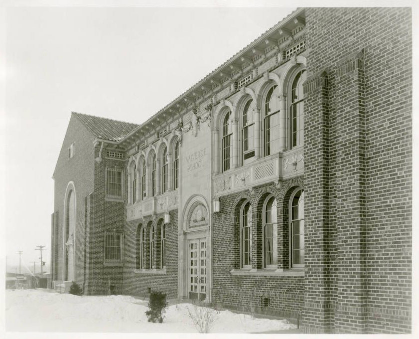
Photo Credit: Denver Public Library Special Collections
[1923] - Photograph of the exterior of Valverde Elementary School located in Denver, Colorado.
The Valverde Neighborhood is one of Denver’s oldest statistical neighborhoods. It’s bordered to the north by 6th Avenue, to the south by West Alameda Avenue, to the east by the South Platte River, and to the west by Federal Boulevard.
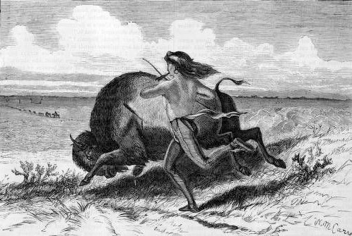
Photo Credit: Denver Public Library Special Collections
[1870?] - A Native American man hunts a buffalo on foot. He carries arrows in his mouth and runs beside the animal, which he has already pierced with one arrow.
Valverde was founded in 1888. Valverde actually used to be its own town separate from Denver, and was incorporated in 1899. Soon thereafter, in 1902, it was disincorporated and annexed by Denver. However, before being settled, the area was known as “niinenii-niicie” or “tallow river” by the Arapaho people. The indigenous population found the area especially prosperous, teeming with buffalo and other wildlife that offered good hunting opportunities, as well as many native plants to gather, such as turnips, plums, and chokecherries.
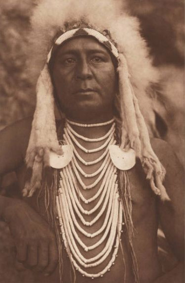
Photo Credit: Denver Public Library Special Collections
Creator: Curtis, Edward S. - Portrait of Alexander B. Upshaw, a Native American (Crow) man, assistant to Edward S. Curtis; he wears heishi bead necklaces, shell disks, ermine fringe, a quillworked headband, and a headdress of down feathers.
The 1851 Treaty of Fort Laramie (also known as the Horse Creek Treaty) laid out that this area was to be governed by the Plains Tribes, including the Arapaho, Cheyenne, Crow, Sioux, and Ute tribes, if they gave European settlers peaceful passage along the Oregon Trail and allowed the U.S. military to establish roads and military posts within their respective territories. In exchange, the indigenous tribes were offered a total of $50,000 annually for 10 years (which was originally supposed to be 50 years), and the U.S. Federal Government promised to protect the indigenous tribe’s resources and tribal hunting grounds from encroachments by European settlers. The promises were never kept, especially as a gold rush into the Rocky Mountain region occurred in 1858 following the discovery of gold near present-day Denver. In fact, the U.S. Government only ever made one payment, thus breaking the treaty.
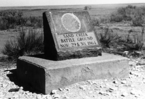
Photo Credit: Denver Public Library Special Collections
Creator: Wilcox, Kay - 1972 - Close up view of a marker that commemorates the Sand Creek Massacre in which United States troops killed some 200 Native Americans (Cheyenne and Arapaho), two thirds of whom were women and children, Kiowa County, Colorado. The marker consists of a wedge shaped piece of granite that is on a rectangular piece of concrete. The marker reads: "Sand Creek Battle Ground Nov. 29 & 30 1864".
After the treaty’s passage, the tribes remained relatively peaceful until the War of 1864 - also known as the Colorado War - began. That year, white settlers’ demands for land and resources pressured the Sioux, Cheyenne, and Arapaho tribes into warfare with American troops, culminating in the Sand Creek Massacre - a genocidal brutality on the part of American troops. After the Sand Creek Massacre, many of the Plains tribes moved north into modern-day Wyoming. By that time, white settlers had hunted the buffalo into near extinction and broken up tribal hunting grounds into private farms and cattle ranches.
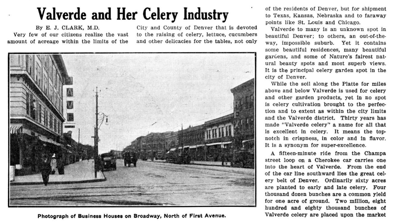
Photo Credit: Denver Public Library Special Collections
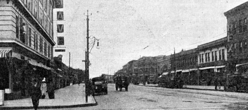
1913 - Newsletter produced semi-monthly by the City of Denver highlighting the civic, administrative, and informational aspects of government within the City.
Valverde is Spanish for “green valley”. Early developers of the area were enticed by the valley’s flourishing natural vegetation near the South Platte River, surrounded by beautiful trees. Small farms flourished in the area, and local farmers would use small trucks to take produce to the market. During the late 1800s through the early 1900s, Valverde was known nationwide for producing high quality celery. After harvesting celery each year, many farmers planted a second crop such as lettuce, alfalfa, or wheat. Over time, irrigation ditches were dug to the farmlands from the Platte River and expanded farmer’s crop options; many were then able to also grow bell peppers, cabbage, and onions.
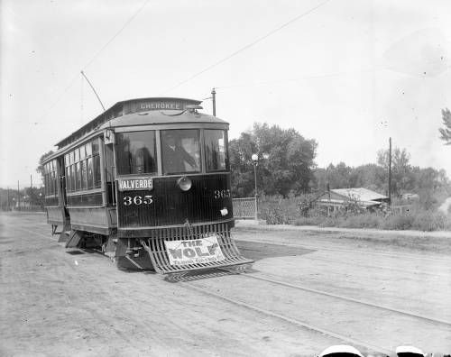
Photo Credit: History Colorado
Creator: Lillybridge, Charles S. - [1910-1925] - View of Denver City Tramway Company trolley car number 365 at is makes its way West, on Alameda Avenue, near the bridge over Archer Canal, Denver, Colorado. Charles S. Lillybridge's house and studio is in the distance. Signs on the trolley car read: "Valverde", "Cherokee", and "The Wolf Tabor Grand".
Modern development began to first take place along today’s Alameda Avenue, east of Tejon Street, the northeast part of what is now Athmar Park, and in the northwestern section of the neighborhood. In 1915, substantial construction activity began occurring in the neighborhood; most small farms began to be redeveloped into industrial buildings, such as warehouses, offices, and other light industrial uses.
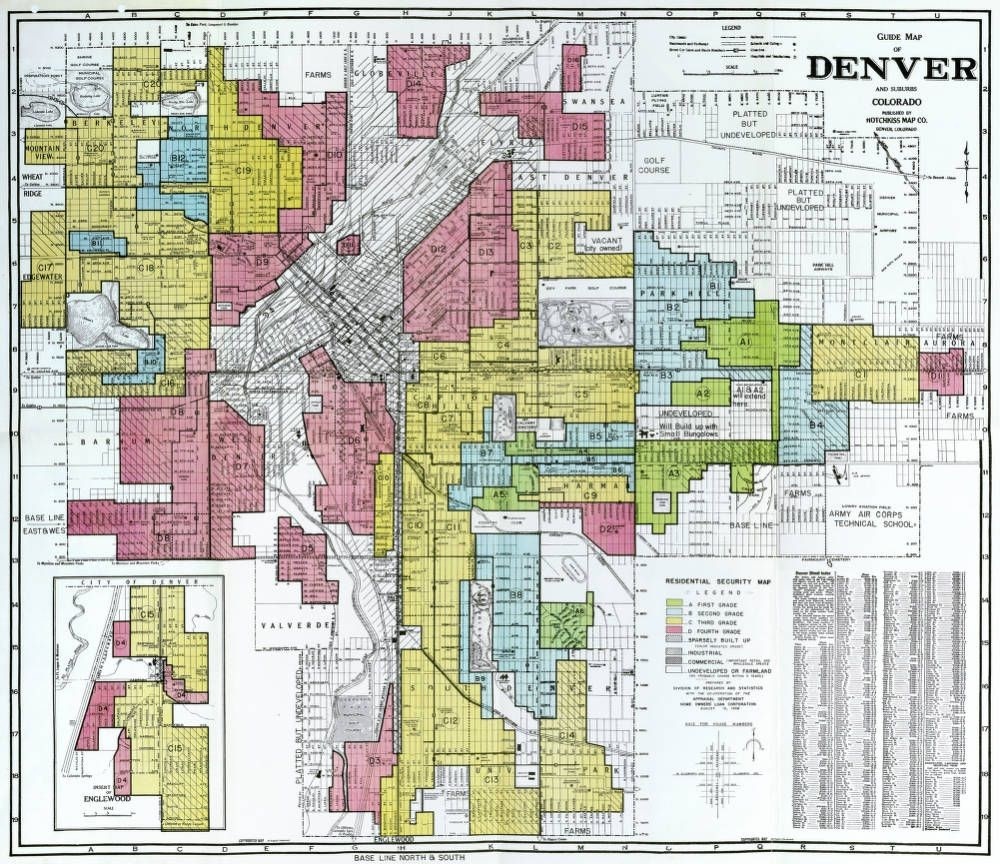
Photo Credit: Original map is owned by the National Archives and Record Administration, Washington, DC. Map digitized from physical reproduction owned by Denver Public Library.
Creator: Home Owners' Loan Corporation - 1938 - Map is dated August 15, 1938 and illustrates the redlining of neighborhoods in the City and County of Denver where minorities were excluded from receiving home loan funds because they were considered poor economic risks.
During the Great Depression, the Home Owners’ Loan Corporation (a government sponsored corporation created as part of the New Deal) created a map that rated neighborhoods nationwide according to their investment potential, with the goal of protecting the government from investing in “risky” land. Neighborhoods that were home to people of color, Jewish communities, or had a high rate of industrial land use were deemed “hazardous”, which was sadly the case for the Valverde neighborhood. The neighborhood specifically was deemed hazardous due to its high concentration of working class residents and immigrant families.
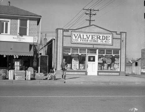
Photo Credit: History Colorado
Creator: Zellers, Bob - [1940-1950?] - View of businesses in the Valverde neighborhood of Denver, Colorado; a woman walks by fruit and a storefront. Signs read: "Quality Meats & Groceries 1205," and "Valverde Feed Store." Window displays read: "Purina Chows, Startena, Growena, and Layena." A woman in jodhpurs approaches.
Despite systemic disinvestment in the area due to its hazardous designation, local businesses along West Alameda were still able to develop and sustain a healthy “main street” business district. Valverde was a tight-knit community through the post-war era. The industrialization of the neighborhood increased during the 1950s and ‘60s with the construction of Interstate 25 and the 6th Avenue Freeway. The government was able to buy the land in this area for a low cost due to its “hazardous” designation. 1-25 was built along the east side of the Valverde neighborhood, isolating it from the rest of Denver, which further contributed to its industrialization. In 1959, Denver’s first shopping mall was built in the Valverde neighborhood. The Alameda Square Shopping Center was an approximately 20-acre site and home to one of the city’s oldest King Soopers locations, a Woolworths, and REI.
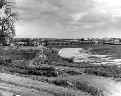
Photo Credit: Denver Public Library Special Collections
Creator: Brennan, Terry - June 16th, 1965 - View of South Platte River flood damage near 1st (First) Avenue and Umatilla Street in the Valverde neighborhood of Denver, Colorado; shows houses, warehouses, smokestacks, and a sign: "King Soopers."
Unfortunately, on June 16,1965, the South Platte River experienced a historical flood. Around 1400 homes located near the river sustained damage or were completely swept away in the flood waters. Approximately 325 homes were condemned, 75 of those being completely lost after being swept away. About 1200 commercial buildings were also damaged. In the Valverde Neighborhood alone, around a half-million dollars of damage was sustained - equivalent to about $5 million today. Around 2500 people lost their homes and 23 people were killed. After this tragic event, many people unfortunately left the neighborhood in search of better opportunities to be able to get a fresh start and rebuild their lives.
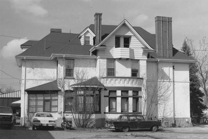
Photo Credit: Auraria Library
Creator: Noel, Thomas J. - 1980 - View of the Joseph W. Fassett House (1890) at 50 South Alcott Street in the Valverde neighborhood of Denver, Colorado. Shows a brick residence which has been painted white. The house has hip roofs, gables, gabled dormers, bays, a balconette and brick chimneys.
By the 1980s, with the increase in manufacturing jobs in the neighborhood, Valverde was a major area of employment in the Denver metro-area, providing jobs to about 5500 people. As industrialization continued to expand, home values decreased along with residential populations, and mobility options and civic institutions were increasingly erased. Sadly, even to this day, neighborhood residents are subjected to disproportionate pollution from highway and industrial traffic.
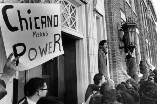
Photo Credit: Denver Public Library Special Collections
Creator: Brock, Howard - February 11th, 1970 - A Mexican-American man speaks into a microphone in Denver, Colorado, during a protest. Picket sign reads: "Chicano Means Power." An ornate lamp is on a brick building with entablature.
Although the period of highway and industrial expansion took a toll on local residents’ health and wealth, the Valverde neighborhood saw an increase in cultural diversity. In I960 the Latino population was only 11%, but had risen to 62% by 1990. Today, the neighborhood’s population is around 4,500 residents, and the majority of residents are working-class Mexican Americans. Denver was central to the Chicano rights movement during the ‘60s and ‘70s, and in 1972, Valverde resident and Chicano activist leader Elaine Ullibarri founded Servicios de La Raza, which to this day remains a center for community life and supportive services for the local Latino population.
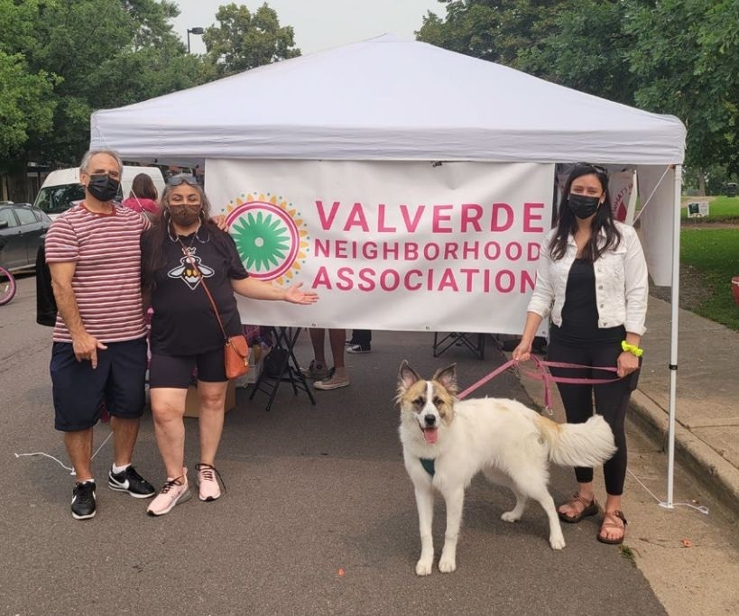
Photo Credit: West Area Plan November Community Meeting
2022 - Valverde Neighborhood Association Booth at a community event.
In 2016, the Valverde Neighborhood Association was founded. The association did away with Denver’s traditional Registered Neighborhood Organization board model and moved towards a donation model to more directly make a positive impact in residents’ lives. Silver Stem Fine Cannabis has supported the Valverde Neighborhood Association’s mission, as our Short Place grow is in the Valverde neighborhood. In 2020, we donated 1000 masks to the association at the height of the COVID-19 pandemic when citizens were facing supply shortages. In spring 2022, we donated to the association to help support a summer flower give-away to help neighbors beautify their yards, and the Denver Days neighborhood event. Later, in fall 2022, we were once again proud to help out the Valverde Neighborhood Association by partnering with them to help provide winter coats for local children. We look forward to continuing to make a positive impact in our neighborhood in coming years.